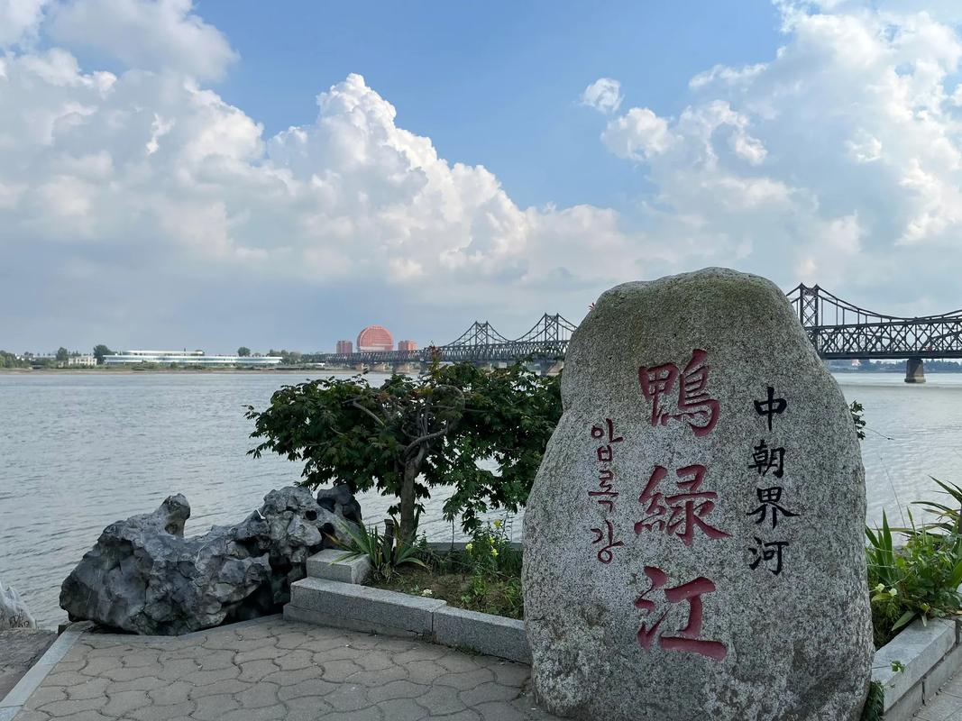
丹东鸭绿江导游词(精选9篇)
丹东鸭绿江导游词 篇1
各位游客:
大家好!
我是旅行社的导游员,首先我代表旅行社、本人和司机师傅向远道而来的客人们表示热烈的欢迎。大家在后面的行程中有什么困难和要求,请及时向我提出,我们将竭诚地为大家提供满意的服务。在此,我预祝大家本次丹东之旅心情愉快。未来几天的行程中,我们大家要互相帮助、互相体贴,使我们这个旅游团成为一个和谐的大家庭。今天,游览各个景点之前,我先给大家介绍一下丹东市的概况。
地理及人口概况
丹东市地处黄海之滨、鸭绿江畔,位于辽宁省东南部,与朝鲜民主主义人民共和国新义州市隔江相望,是一座以工业、商贸、物流为主的沿江、沿海、沿边城市。丹东行政区划面积
1.52万平方公里,总人口243万。其中市区面积831平方公里,人口76.5万。辖三县(市)三区和一个国家级边境经济合作区。1988年,经国务院批准,丹东成为沿海开放城市。20__年,被列入辽宁沿海“五点一线”重点发展区域。20__年,全地区实现生产总值463.86亿元,比上年增长16.1%。全口径财政收入65.79亿元,增长26.7%;全社会固定资产投资233.8亿元,增长45.4%。社会消费品零售总额162亿元,增长17.2%。城镇居民人均可支配收入9815元,增长24.9%。农民人均纯收入5543元,增长19.2%。实际利用外资1.47亿美元,增长28.3%。外贸出口16.2亿美元,增长15.2%。
产业门类比较齐全——丹东规模以上工业企业883户,分布在36个行业大类中,目前已形成了交通运输设备制造业、纺织服装业、电子信息和仪器仪表制造业等优势产业。黄海客车、曙光车桥、化纤等产品在国内拥有各类发电站十余个,集水电、火电、风电于一身,电力总装机容量达到159万千瓦,三至五年将达到500万千瓦。农业已初步形成海水精品渔业带、鸭绿江珍品渔业带和优质稻米、板栗、草莓、蓝莓等特色农业基地,是全国最大的草莓、板栗和贝类养殖生产和出口基地。
自然禀赋得天独厚——丹东依山、临江、傍海,景色优美,气候宜人,夏无酷暑、冬无严寒,年平均气温9°C,属温带季风大陆性气候,南部属于半大陆半海洋性气候。环境空气质量全年好于国家二级水平,全市森林覆盖率达到66%,年降水量800—1200毫米,地表径流千余条,水库57座,人均水量是全国人均水量的1.6倍,是辽宁省的4.5倍。境内海岸线长126公里,多处可发展港口、造船、旅游、发电等产业。滩涂面积328平方公里,海域水质好、营养盐含量高,具有发展水产养殖业的良好条件。素有“北国江南”之美誉,是东北地区最温暖湿润的地方,也是最适合人类居住的城市之一。
人文历史悠久厚重——丹东原名“安东”,源于唐代设置的安东都护府,一直是我国东北的商贸重镇和军事要地。1876年设立县,1906年开埠通商,1945年——1954年为辽东省省会。1982年在东沟县(现丹东东港市)发现的“前阳人”洞穴遗址,证明早在1.8万年以前我们的祖先就劳动、生息、繁衍在这块富饶的土地上了。秦统一全国后,丹东属辽东郡。西汉时在丹东设置武茨县和西安平县,这是丹东最早的城池.也是东北地区最早设置的县级行政单位之一。唐高宗总章元年(公元668年)设置安东都护府(安东市市名即源于此)。清光绪二年(公元1876年),清政府设凤凰厅和安东县,次年设宽甸县,并以凤凰厅为首府统辖全境。1937年12月1日安东市正式成立。1965年,国务院决定改安东市为丹东市,含义是“红色东方之城”。
丹东是一个多民族地区,有汉、满、蒙、回、朝鲜、锡伯等36个民族。因此,丹东拥有满族、朝鲜族等多民族的文化风土民情。在少数民族中,满族人口最多,占全市人口的32%,是全国最大的满族聚居区,是满族重要的发祥地之一。
气候和城市环境
丹东属温带气候,四季分明,冬暖夏凉。年平均降水量为800——1200毫米左右,是中国北方地区最湿润的地方。
春季大地回春,正是观赏丹东市花—杜鹃花的最佳季节。夏季凉爽,游人纷纷来到丹东海滨或风景区避暑度假。秋季雨量减少,气候凉爽宜人,丹东市树—银杏树已是果实累累、一片金黄;环顾鸭绿江沿岸的各个景区,红叶满山,恰似彩锦织成的秋装。丹东市城市绿化覆盖率高(66%),全年空气质量达标率为94.8%。丹东不愧为是人居佳地,希望有识之士来丹东投资、安家落户,颐养天年。
旅游资源和旅游业
丹东旅游资源占地面积1500平方公里,占辖区国土面积的10%。拥有国家、省级以上旅游风景区、自然保护区和森林公园24处。中朝界河鸭绿江流经丹东210公里,沿途6大景区、100多个景点构成一幅独具风格的边陲画卷和蔚为壮观的鸭绿江百里文化旅游长廊。丹东是全国“市民最满意城市”20强之一。丹东矿藏资源达64种,是中国著名的“硼都”,储量占全国90%以上,位居全国首位。黄金储量占全省黄金总量的37.2%居全省前列。丹东地热资源丰富,天然露点17处,是东北著名的温泉疗养胜地。
丹东是优秀旅游城市,也是辽宁省的旅游热点城市(与沈阳、大连构成辽宁旅游“金三角”)。丹东旅游资源非常丰富,境内有:
国家重点风景名胜区三个——鸭绿江风景名胜区、青山沟风景名胜区、凤凰山风景名胜区;国家4A级旅游景区六个——凤凰山风景名胜区、鸭绿江风景名胜区、天华山风景名胜区、五龙山风景名胜区、丹东宽甸天桥沟国家森林公园、丹东抗美援朝纪念馆;
国家级自然保护区两个——白石砬子国家级自然保护区、丹东鸭绿江口滨海湿地国家级自然保护区;
国家级森林公园两个——天桥沟、大孤山;
全国重点文物保护单位有凤凰山山城、鸭绿江断桥、虎山长城。
全国爱国主义教育基地:抗美援朝纪念馆,鸭绿江断桥;
目前我市已拥有国家、省级重点风景名胜区、自然保护区等24处。还有著名的大孤山天后宫,是我国历史最大的天后宫古建筑群。被专家们誉为“旷世佳境,万景奇山”——天华山森林公园和天然火山博物馆——黄椅山森林公园。
丹东还有许多的古文化遗址;有近代日俄战争、中日甲午海战场,杨靖宇烈士的遗迹、轶事等红色旅游资源;
“全国农业旅游示范单位”大梨树国家生态农业旅游区由花果山、药王谷、联珠三湖、仿古新村、休闲游乐区五部分组成。其山水田园风光、传统中医药文化、满族农家菜肴和金秋自助采摘等自成特色,深受游人喜爱。
你乘坐鸭绿江上游船,沿江而行观赏到两岸风光,您体会的是两国的风情。赴朝旅游也是丹东旅游业的特色项目,中国赴朝旅游的游客有80%以上是从丹东口岸出境,您来到丹东也可以顺便到朝鲜去看看,领略一下这个神秘国度的风采。
丹东土特产品和名吃
丹东土特产品品种繁多,人参、板栗、草莓、山楂、柞蚕、食用菌、林蛙、对虾等产品闻名遐迩,远销国内外。水产品有各种贝类如:海螺,玉螺,扇贝,赤贝,杂色蛤,梭子蟹等。鱼类如:鱿鱼,马鲛鱼,海鲜串等。由于鸭绿江和大洋河水流入黄海,丹东的水产品是在咸水和淡水“两合水”环境生长的,因此有着独特的美味,再加上酒店厨师独特的烹饪技术,吃起来那真是一个美,在其他地方是品尝不到的。到丹东不品尝海鲜,那是一个“悔”,各位一定要品尝丹东海鲜,一饱口福。此外还有满族的“酸汤子”,朝鲜族的“打糕”,丹东的“烧烤”等等地方小吃,通过品尝这些小吃,必能感受到丹东民俗风情和多民族文化。丹东基础设施和城市定位。
丹东的基础设施完备,交通便利,已形成海、陆、空立体交通体系。丹东铁路距平壤220公里,距首尔420公里,莫斯科――北京――平壤的国际联运列车途经丹东出入国境。公路201、304国道在此交汇,丹东-沈阳、丹东-大连两条高速公路和正在实施以及已经列入规划中的东北东部铁路工程、沈丹铁路复线、丹通高速公路、丹海高速公路、丹庄铁路、海空港扩建等基础设施项目的建设,将使丹东处在四条高速公路、三条铁路的中心交汇位置。丹东港是我国大陆海岸线最北端的天然不冻良港和国际贸易商港,已同日本、韩国、朝鲜、俄罗斯、美国、香港等50多个国家和地区的70多个港口开辟货运和客运航线。丹东港位于我国最东部,由于位置特殊,必将在振兴东北经济中发挥重要的作业。丹东民航机场现已开通丹东至北京、上海、深圳、三亚和韩国汉城的航线。
丹东市实施“四大”战略的主要内容:市委市政府提出当前和今后一个时期,全市要坚定不移地实施“坚持大开放、狠抓大项目、构建大旅游、营造大环境”的四大战略。
实施“大开放”的拉动战略——就是要努力构建开放型经济体系、大力推动临港产业园区的快速发展,最大限度地发挥港口的牵动和带动作用,实施全方位、宽领域、多渠道对外开放。千方百计加强对外交流与合作,大幅度提高域外投资比重和临港产业园区经济规模,经过三、五年努力,使丹东成为东北地区具有较强竞争力的重要沿海开放城市。
实施“大项目”的牵动战略——就是要努力抓住当前难得的机遇,强化招商引资工作,多上、快上大项目、好项目,特别是以工业大项目为牵动,加快我市经济发展方式转变和结构调整,尽快步入又好又快的发展轨道。培养一批国家和省级名牌产品,提高规模工业占地区生产总值的比重,经过三、五年努力,形成在国内有较强影响力和稳定支撑力的优势产业集群,增强丹东城市的总体经济实力。
实施“大旅游”的带动战略——就是要努力建设以鸭绿江为核心的复合型精品旅游带,突出丹东的名江、边境、长城、海角等全国具有惟一性的资源优势,建设红色旅游、生态旅游、边境旅游,海洋旅游四大板块。通过旅游业的发展,促进和带动相关产业的发展壮大,经过五年的努力,把鸭绿江打造成集人文与自然风光于一体的世界级旅游品牌,增强丹东城市的吸引力。
实施“大环境”的推动战略——就是要努力加强软环境建设,创造良好的发展环境和社会环境,完善投资政策和城市功能,拓展城市的发展空间,改善和关注民生,提高城市品位,打造宜居城市,经过三、五年努力,把丹东建设成为布局合理、设施完善、交通便捷、信息发达、环境优美、生态平衡、经济繁荣、社会文明、可持续发展的现代化城市。
丹东是辽宁省“五点一线”沿海经济带东端的起点。丹东市将以“旅游名城、人居佳地、工业强市、商贸重镇”为新的建设目标,新的交通格局的形成将有利于丹东市的全面发展。各位游客,伴随着丹东市经济的腾飞,江城丹东必将更加美丽,希望各位再次来丹东旅游,我们将一如既往的欢迎你们,期待你们。
丹东鸭绿江导游词 篇2
各位游客:
大家好!
欢迎参观丹东鸭绿江风景区!
鸭绿江风景名胜区位于鸭绿江中下游丹东市境内,东起浑江口,西至大东港,全长210公里,总面积824.2平方公里。风景区与朝鲜新义州隔江相望。这里地理位置优越,气候冬暖夏凉,山青水秀,一览中朝两国风光而独具特色。
鸭绿江因为水的颜色而得名,那碧绿的江水,犹如雄鸭脖颈的莹绿,先人们便称其为鸭绿江,沿袭至今。鸭绿江发源于吉林省长白山南麓,流经长白、集安、宽甸、丹东等地,向南注入黄海,全长795公里,是中朝两国的界河。鸭绿江流经丹东市约300公里。此段江面宽阔,两岸风光秀丽,在入海口一带,盛产大银鱼。
鸭绿江造桥历史很早,可上溯到辽代,20世纪初,鸭绿江上始建铁桥,先后在丹东和朝鲜新义州之间建了二座。第一座建于1909年,是座开闭式桥梁。1950年朝鲜战争中被美国飞机炸毁,桥墩至今犹存,现辟有端桥游览区。第二座桥建于1940出年,为铁路、公路两用桥,全长940米,属中朝两国共管。它是中朝两国的交通要道,也是游人观光览胜的景点。
现在我们看到的就是第一座大桥,又被称作‘断桥’。1909年建,被美机炸断,由日本朝鲜总督府铁道局建造。这是条单线铁路桥,桥面为直梁划板式。在抗美援朝战争中,断桥是志愿军出国的主要通道,也是运输战略物资的大动脉。1950被美机炸断,成为废桥。93年开放为景点供人们游览。
侧面的这个炮楼,就是当年日本警备队守桥的主要工事地。这5层炮楼是我国目前现存最完好的公路防御炮楼,也是日本侵华战争的铁证。
在我们左侧不到100米的地方,是第二座大桥,也是著名的‘鸭绿江中朝友谊桥’。这座桥是复线铁路桥。大桥上行铁路,下行公路。当时公路桥面铺设木板,一九七七年换铺水泥板后就再没有修过。多年没有大修过的鸭绿江大桥钢梁已锈蚀斑斑,路面破损多达三百余处,有的桥面板移位、断裂,致使大桥承重能力减弱。
朋友们,我们现在所在的位置是虎山景区。虎山景区位于中朝界鸭绿江江畔,主要有长城、睡美人、中朝边境一步跨、古栈道等景点。其中,最具代表性的景点便是虎山长城。
虎山长城于丹东市宽甸县虎山乡。距据考证,它大约始建于1469年,是我国明朝万里长城的东端起点。它横跨祖国的千山万水,西与甘肃的嘉峪关长城相连,可称的上是古人留下的一座建筑丰碑。
我们现在看到的长城是1992年重修的。修复后的虎山长城以砖石结构为主。本着文物“修旧如旧”的原则,修复后的长城走势和各个敌楼、墙台、烽火台的位置都与文物考古发现原址相符合,基本上再现了历史上虎山长城的雄姿。
这座山就是虎山,它是突起于鸭绿江的一座孤山。仔细看一下,很像一只猛虎蹲坐在那里,所以这里得名虎山。现在请随我登上长城。明长城的建筑结构非常完备,包括城墙、城台、敌台、烽火台、关口等部分,在这虎山长城基本都可以看到。这是虎山峰顶,为明朝万里长城的第一个烽火台。站在烽火台上放眼眺望,江城丹东的高楼大厦和朝鲜新义州市尽收眼底。
应该说,博大精深的长城文化,已经深深地凝聚了我们的民族精神。长城,作为历史的丰碑,将永远屹立在一个伟大民族的心灵深处!
欢迎再次光临丹东鸭绿江风景区。再见!
丹东鸭绿江导游词 篇3
各位游客:
大家好!
欢迎来到鸭绿江风景名胜区参观游览,下面请大家听我介绍一下鸭绿江风景名胜区的概况。
一、景区概况
鸭绿江风景名胜区,是国务院于1988年批准的国家重点风景名胜区,地处鸭绿江下游,浑江口至大东港之间,与朝鲜的碧潼、清水、义洲和新义州隔江相望,全场210公里,面积824.2平方公里。
鸭绿江风景名胜区由绿江、水丰、太平湾、河口、虎山、大桥和江口等景区100多个景点组成,以自然风光旖旎,人文景观荟萃、地理区位独特、环境质量优越而驰名中外,是一览两国风光,凭吊历史遗迹,融休闲度假、科学考察和异国旅游于一体的河川型风景名胜区。
鸭绿江风景区20__年被国家旅游局评为AAAA级旅游景区,20__年荣获辽宁省“十佳”旅游区,20__年虎山长城、鸭绿江断桥升为国家重点文物保护单位,20__年获全国十佳休闲景区称号,20__年被评为辽宁省文明景区。
二、绿江景区
绿江景区位于宽甸振江乡,从东江至浑江口,面积141平方公里,为鸭绿江景区上游。这里层峦叠嶂,风景秀丽、野趣横生,由南天门、小青沟、壮哉谷等景点组成,至今仍保持着原始状态,处于待开发阶段。
三、水丰景区
水丰景区以水丰水库为核心,面积为274平方公里,建成于1941年的水丰大坝,长900米,高146米,宽8.5米,为世界少见的水泥结构高坝。素有东北第一大水库和辽宁第一大淡水湖之称的水丰湖,因开发较晚儿完整地保存了自然风貌。
湖面浩瀚壮阔,山水相映,空气清新,既有北方山水的雄浑壮美,又有江南山水的清秀之美。水丰湖面由中朝两国共管,船只只在水面上自由来往停泊,游人尽可饱览两岸风光和异国风情。
四、太平湾景区
太平湾景区距丹东市50公里,与朝鲜平安北道朔州郡隔江相望,主要由古渡新村和太平湾电站等景点组成。其中太平湾电站为景区核心,是全国工业旅游示范点。在这里可以直观地看到“水是怎样发电的”,并踏上朝鲜土地感受异国风情。
五、河口景区
河口景区位于宽甸县长甸镇境内,素有“塞外江南”之美誉,是鸭绿江沿线景区景色最优美的地方,也是一个汇集自然景观、人文景观、历史遗迹、民俗民风及异国风景的超浓缩型综合景区。
自然景观有著名歌唱家蒋大为唱红大江南北的《在那桃花盛开的地方》中的万亩桃花园,人文景观有电视剧《刘老根》中的“龙泉山庄”,具有深刻教育的意义的渡江作战的“河口断桥”,原名“清城桥”,是鸭绿江上的第一座公路桥。
六、虎山景区
虎山景区是鸭绿江国家级风景名胜区的核心景区,为国家重点文物保护单位,与“朝鲜八大景”之一的统军亭隔江相望。景区内有明万里长城东端的起点--虎山长城、中朝边境“一步跨”等景点。从一定意义上说,虎山景区是一处以古代军事文化遗址旅游为主题,以边境旅游和红色旅游为特色的著名景区。
七、丹东市城区
丹东市城区段属于鸭绿江风景名胜区中著名的大桥景区,有宝山悬红,碧水玉榭、鸭江帆影等著名景点。其中,断桥原是鸭绿江的第一座大桥,由当时的殖民机构--日本驻朝鲜总督府铁道局承建,1909年8月动工,1911年10月竣工,长944.2米,宽11米,共12孔,始为铁路桥。
1950年11月8日,“第一桥”被美军飞机多次轰炸称为残桥保留至今,俗称“断桥”。桥上保存碉堡等文物遗迹,并开设有大桥旋转处观赏台、断桥炸断处观赏台、断桥史话,世界桥梁与战争史展等。
登上断桥处不仅可以领略中朝两国风光,更是人们凭吊历史、缅怀英烈、激发爱国之情的游览胜地,鸭绿江断桥已经成为丹东这座英雄城市的标志性景点。第二座桥建于1940年,为铁路、公路两用桥,全场940米,归中朝两国共管。
八、江口景区
江口景区是鸭绿江风景区名胜区最南端的一个景区,从江口至文安岛北端,面积为246平方公里,大东岗区的江海分界线时中国海岸线的最北端,三号江海界碑吸引了许多游客。
好了,我的讲解就到此结束了,祝大家有一个愉快的旅行。
丹东鸭绿江导游词 篇4
大家好,现在大家看到的就是鸭绿江大桥。鸭绿江大桥是横跨中朝两国的国境桥。它是一座历史的丰碑,历经抗美援朝战火的洗礼,铭记着中朝两国人民用鲜血和生命凝成的伟大友谊。现在,我们依然能清晰的看到桥梁铁架上的众多弹痕和残留的弹孔。1950年,我志愿军35万人马就是从这座桥上雄赳赳、气昂昂,跨过鸭绿江的。这座大桥始建于1935年,1950年8月份,美军出动数十架飞机侵入临江上空,向鸭绿江大桥和附近的临江火车站狂轰滥炸,大桥靠近朝鲜的一端被炸毁,1955年5月,中朝双方重新将友谊之桥修复畅通。桥长600余米,高20米,宽10米。
这里有个历史故事,我们一起来了解一下。1950年8月11日,当4架敌机向停在临江火车站一列装满作战物资的机车扫射轰炸时,临江火车司机徐国臣,冒着生命危险,冲进机车驾驶室,将军列向等避洞开去,敌机立即跟踪追炸,向列车头狂扫不止,徐国臣驾驶机车的四个手指头被打掉,鲜血直流,但仍坚持将列车开进了山洞,保住了机车。1951年,徐国臣被评为抗美援朝特等功臣,受到了毛主席的接见。徐国臣舍身救列车的英雄事迹很快传遍了全国,极大地鼓舞了全国军民保家卫国,抗美援朝的热潮。来到桥上,人们凭吊英灵,缅怀先烈,企盼世界永远和平,眼前仿佛又看到了志愿军铁流滚滚,雄师劲旅的雄姿和风采。
鸭绿江大桥其实有两座,相隔不足百米。第一座桥于5月动工,10月竣工,由当时的日本朝鲜总督府铁道局所建,始为铁路桥,十二孔,长944.2米,宽11米,从中方数第四孔为开闭梁,可旋转90度,便于往来船只航行。第二座桥始建于1937年4月,1943年启用,距第一座桥上游不足百米。1950年11月——1951年2月,经美国飞机多次轰炸,第一座桥毁为废桥,只剩下半截,朝鲜一侧只留下光秃秃的几个桥墩。
第二座桥也就是我们经常说的鸭绿江大桥还在使用中,是联系中朝两国的纽带。这座桥于一九三七年开工建设,一九四三年交付使用。大桥上行铁路,下行公路。当时公路桥面铺设木板,一九七七年换铺水泥板后就再没有修过。多年没有大修过的鸭绿江大桥钢梁已锈蚀斑斑,路面破损多达三百余处,有的桥面板移位、断裂,致使大桥承重能力减弱。
新的鸭绿江大桥项目正在规划与洽谈中。横跨鸭绿江两岸,为连接中朝两国的重要桥梁,是丹东与朝鲜之间新的交通要道,也是未来鸭绿江江面之上的一大景观点。大桥采用斜拉索形式,体现现代主义的设计精髓,造型优美、气势磅礴。
丹东鸭绿江导游词 篇5
欢迎参观丹东鸭绿江风景区!
鸭绿江风景名胜区位于鸭绿江中下游丹东市境内,东起浑江口,西至大东港,全长210公里,总面积824.2平方公里。风景区与朝鲜新义州隔江相望。这里地理位置优越,气候冬暖夏凉,山青水秀,一览中朝两国风光而独具特色。
鸭绿江因为水的颜色而得名,那碧绿的江水,犹如雄鸭脖颈的莹绿,先人们便称其为鸭绿江,沿袭至今。鸭绿江发源于吉林省长白山南麓,流经长白、集安、宽甸、丹东等地,向南注入黄海,全长 795公里,是中朝两国的界河。鸭绿江流经丹东市约300公里。此段江面宽阔,两岸风光秀丽,在入海口一带,盛产大银鱼。
鸭绿江造桥历史很早,可上溯到辽代,20世纪初,鸭绿江上始建铁桥,先后在丹东和朝鲜新义州之间建了二座。第一座建于,是座开闭式桥梁。1950年朝鲜战争中被美国飞机炸毁,桥墩至今犹存,现辟有端桥游览区。第二座桥建于1940出年,为铁路、公路两用桥,全长940米,属中朝两国共管。它是中朝两国的交通要道,也是游人观光览胜的景点。
现在我们看到的就是第一座大桥,又被称作‘断桥’。建,当时是0年,被美机炸断,由日本朝鲜总督府铁道局建造。这是条单线铁路桥,桥面为直梁划板式。在抗美援朝战争中,断桥是志愿军出国的主要通道,也是运输战略物资的大动脉。1950被美机炸断,成为废桥。93年开放为景点供人们游览。
侧面的这个炮楼,就是当年日本警备队守桥的主要工事地。这5层炮楼是我国目前现存最完好的公路防御炮楼,也是日本侵华战争的铁证。
在我们左侧不到100米的地方,是第二座大桥,也是著名的‘鸭绿江中朝友谊桥’。这座桥是复线铁路桥。大桥上行铁路,下行公路。 当时公路桥面铺设木板,一九七七年换铺水泥板后就再没有修过。多年没有大修过的鸭绿江大桥钢梁已锈蚀斑斑,路面破损多达三百余处,有的桥面板移位、断裂, 致使大桥承重能力减弱。
朋友们,我们现在所在的位置是虎山景区。虎山景区位于中朝界鸭绿江江畔,主要有长城、 睡美人、中朝边境一步跨、古栈道等景点。其中,最具代表性的景点便是虎山长城。
虎山长城于丹东市宽甸县虎山乡。距据考证,它大约始建于1469年,是我国明朝万里长城的东端起点。它横跨祖国的千山万水,西与甘肃的嘉峪关长城相连,可称的上是古人留下的一座建筑丰碑。
我们现在看到的长城是1992年重修的。修复后的虎山长城以砖石结构为主。本着文物“修旧如旧”的原则,修复后的长城走势和各个敌楼、墙台、烽火台的位置都与文物考古发现原址相符合,基本上再现了历史上虎山长城的雄姿。
这座山就是虎山,它是突起于鸭绿江的一座孤山。仔细看一下,很像一只猛虎蹲坐在那里,所以这里得名虎山。
现在请随我登上长城。明长城的建筑结构非常完备,包括城墙、城台、敌台、烽火台、关口等部分,在这虎山长城基本都可以看到。
这是虎山峰顶,为明朝万里长城的第一个烽火台。站在烽火台上放眼眺望,江城丹东的高楼大厦和朝鲜新义州市尽收眼底。
应该说,博大精深的长城文化,已经深深地凝聚了我们的民族精神。长城,作为历史的丰碑,将永远屹立在一个伟大民族的心灵深处!
欢迎再次光临丹东鸭绿江风景区。再见!
丹东鸭绿江导游词 篇6
各位游客你们好!我是导游员,今天,我陪同大家游览鸭绿江。现在我们来到了中朝的界河鸭绿江。
鸭绿江是辽宁省第二大河流,江水蜿蜒舒缓,碧波浩渺,直接注入黄海。沿岸青山层峦叠翠,几十道峡谷幽深奇奥,江中大小岛屿星罗棋布,加之褶皱奇特的江岸,苍秀繁茂的植被,珍惜奇异的鸟兽,构成了以水景为重点,山景相呼应,山水层次分明,借景朝鲜风光纷繁绚丽的自然景观。
鸭绿江风景区在我国这一侧有绚丽多彩的自然景观,虎山长城、近代日俄战争遗迹,现代桥梁和大型水利工程,组成丰富的人文景观。现在划分为六大景区,即江口、大桥、虎山、太平湾、水丰、绿江景区(有关六大景区的详细资料请见《走进鸭绿江》一书)。
丹东市就位于美丽的鸭绿江边,位于核心景区的沿江沿海平原上,她有“万里海疆第一边城”之称——万里海疆(1.8万公里的海岸线东端——西端为北仑河口)的东端起点;中国最大的边境城市。
流经丹东市境内的鸭绿江段,东起浑江口,西至大东港,全长210公里(请您注意鸭绿江发源于长白山,全长795公里,上游段位于吉林省境内)。总流域面积61900平方公里,中国一侧32500平方公里,丹东境内11700平方公里。
鸭绿江因为水的颜色而得名,碧绿的江水,犹如雄鸭脖颈的莹绿,人们便称其为鸭绿江,沿袭至今,在很早以前,鸭绿江的古称为马訾水。
您看:右岸就是有着十年历程的丹东市商贸旅游区,现代化的城市建设赋予了中国最大的边境城市以新的生命力;连绵数十里的城市建筑让人们更加体会到江城人对水的偏爱。
在右岸,有一条世界上最长的边境滨江观光大路,这就是丹东市的鸭绿江景观大道。这条与鸭绿江并行的大道一直延伸到上游的虎山脚下。巍巍虎山屹立在江边,俯视着秀美的鸭绿江,见证者悠久的历史。
在右岸,人们或漫步于江边美丽的广场,或戏水于江上;人们尽情地以各种方式玩水,享受着大自然赋予江城的独特美丽,创造着新时代的凯歌!
您看:左岸是朝鲜的新义州。丹东市与朝鲜碧潼、清水、义州、新义州隔江相望。
那是一片吸引世界目光的国度。那是一片曾经燃烧战火的土地。新中国几十万的优秀儿女血洒在那片土地上,用鲜血凝成了中朝友谊,用鲜血换来了和平。
人在江上游,江水船下流。是鸭绿江造就了了两岸美丽的风景,是鸭绿江养育了两岸勤劳的人民。看到这水清如碧的鸭绿江,您也许会问,鸭绿江是中国北方第几大河流(辽宁第二大河流,黄河以北地区流量最大的河流——流域内是中国北方降水量最多的地方)?鸭绿江与国内著名的河流有何不同?不同之处就在于一江鸭水向西流,只要您翻开中国地图,万里海疆的东端起点就是鸭绿江河口(她与最南端的北仑河口相距1万8千公里)。由于上游修建了几座大型水库,如今鸭绿江的水位较低,很难行使大型船只了。
游船载着我们尽可能地靠近对方的岸边行走,这就是鸭绿江旅游的一大特色——只要不登上对岸就不算越界,这种情况在所有的界河中是不多见的。
大家看:前面那座飞跨鸭绿江的“中朝友谊桥”是丹东至新义州的铁桥。它于1937年4月动工兴建,1943年5月竣工,全长940.8米。在它的旁边有一座断桥——就是鸭绿江断桥。
鸭绿江断桥是鸭绿江上第一座桥,5月动工,10月竣工。由当时日本朝鲜总督府铁道局所建。始为铁路桥,十二孔,长944.2米。从中方数第四孔为开闭梁,以四号墩为轴,可旋转90°,便于过往船只航行。
伪满时期,日本人在此桥上游建成第二座铁路大桥(即今日之中朝友谊桥),一九四三年四月启用,逐将第一桥改为公路桥。一xx0年十一月至一一年二月经美军飞机多次轰炸中方一侧剩四孔残桥保留至今。
大家看,当年美国飞机射穿的弹孔依然留在桥梁上。那是历史的见证。现在这座断桥为市级文物保护单位,也是全国的爱国主义教育基地。大家想一想,为什么桥身漆成浅蓝色?那就是意在不忘战争,祈盼和平。
感谢大家游览鸭绿江,我们将继续游览鸭绿江风景名胜区的其他景区。
丹东鸭绿江导游词 篇7
Welcome to Yalu River scenic spot in Dandong!
Yalu River scenic spot is located in Dandong City in the middle and lowerreaches of Yalu River. It starts from Hunjiang estuary in the East and ends atdadonggang in the west, with a total length of 210 kilometers and a total areaof 824.2 square kilometers. The scenic spot faces Sinuiju across the river. Ithas a superior geographical location, warm in winter and cool in summer,beautiful mountains and waters, and unique scenery of China and Korea.
The Yalu River is named for its color. The green water is just like theglittering green of a male duck's neck. People first called it the Yalu River,and it has been handed down to this day. The Yalu River originates from thesouthern foot of Changbai Mountain in Jilin Province, flows through Changbai,Ji'an, Kuandian, Dandong and other places, and flows southward into the YellowSea, with a total length of 795 km. It is the boundary river between China andKorea. The Yalu River flows about 300 kilometers through Dandong City. Thissection of the river is wide, beautiful scenery on both sides, in the estuaryarea, rich in silver carp.
The Yalu River Bridge has a long history, which can be traced back to theLiao Dynasty. At the beginning of the 20th century, the Yalu River began tobuild iron bridges, and two bridges were built between Dandong and Sinuiju. Thefirst one, built in 1909, is an open and closed bridge. In 1950, it was bombedby American aircraft in the Korean War. The pier still exists today, and nowthere is a tourist area of end bridge. The second bridge, built in 1940, is adual-purpose railway and highway bridge with a total length of 940 meters, whichis jointly managed by China and Korea. It is the main traffic route betweenChina and North Korea, and also a scenic spot for tourists.
Now what we see is the first bridge, also known as "broken bridge". It wasbuilt in 1909 and then in 1900. It was blown off by US aircraft and was built bythe Railway Bureau of the Korean governor's office in Japan. This is a singletrack railway bridge with straight beam and slab. In the war of resisting U.S.aggression and aiding Korea, the broken bridge was the main channel for thevolunteers to go abroad and the main artery for transporting strategicmaterials. In 1950, it was blown off by American aircraft and became a wastebridge. It was opened in 1993 as a scenic spot for people to visit.
The turret on the side is the main fortification site of the Japanesepolice force guarding the bridge. The five storey turret is the most intactexisting highway defense turret in China, and also an irrefutable evidence ofJapan's war of aggression against China.
Less than 100 meters to our left is the second bridge and the famous "YaluRiver China DPRK friendship bridge.". This bridge is a double track railwaybridge. The bridge goes up the railway and down the highway. At that time, thebridge deck of the highway was paved with wooden boards, but it was replacedwith cement boards in 1977. The steel beams of Yalu River Bridge, which has notbeen overhauled for many years, have been corroded and the pavement has beendamaged to more than 300 places. Some bridge decks have been displaced andbroken, resulting in the weakening of the bearing capacity of the bridge.
Friends, we are now in Hushan scenic area. Hushan scenic spot is located onthe Bank of the Yalu River in the Sino Korean border. It mainly includes theGreat Wall, sleeping beauty, one-step cross of the Sino Korean border, ancientplank road and other scenic spots. Among them, the most representative scenicspot is Hushan Great Wall.
Hushan Great Wall is located in Hushan Township, Kuandian County, DandongCity. According to research, it was built in 1469, which is the starting pointof the east end of the great wall of Ming Dynasty. It spans thousands ofmountains and rivers of the motherland, and is connected with the great wall ofJiayuguan in Gansu Province in the West. It can be called a monument left by theancients.
The Great Wall we see now was rebuilt in 1992. The restored Hushan GreatWall is mainly of masonry structure. In line with the principle of "repair theold as the old" of cultural relics, the trend of the restored great wall and thepositions of the enemy towers, wall towers and beacon towers are consistent withthe original sites of cultural relics and archaeological discoveries, basicallyreproducing the majestic appearance of Hushan Great Wall in history.
This mountain is the tiger mountain. It is an isolated mountain protrudingfrom the Yalu River. If you look at it carefully, it looks like a tigersquatting there, so it's named Hushan.
Now please follow me to the Great Wall. The architectural structure of theMing Great Wall is very complete, including the city wall, city tower, enemytower, beacon tower, gateway and other parts. You can basically see the Hushangreat wall here.
This is the peak of Hushan, the first beacon tower of the Great Wall inMing Dynasty. From the beacon tower, you can have a panoramic view of thehigh-rise buildings in Dandong and the city of Sinuiju.
It should be said that the Great Wall culture has deeply embodied ournational spirit. The Great Wall, as a historical monument, will always stand inthe heart of a great nation!
Welcome to Yalu River scenic spot in Dandong again. bye!
丹东鸭绿江导游词 篇8
Hello, everyone. Welcome to the Yalu River scenic spot. Now, please listento me to introduce the general situation of the Yalu River scenic spot.
1、 Overview of scenic spots
Yalu River scenic spot is a national key scenic spot approved by the StateCouncil in 1988. It is located in the lower reaches of Yalu River, betweenhunjiangkou and dadonggang, and across the river from Bitong, Qingshui, Yizhouand xinyizhou of Korea. It covers an area of 824.2 square kilometers and covers210 kilometers.
Yalu River scenic spot is composed of more than 100 scenic spots, such aslvjiang, Shuifeng, Taiping Bay, Hekou, Hushan, Daqiao and Jiangkou. It is famousat home and abroad for its beautiful natural scenery, cultural landscape, uniquegeographical location and superior environmental quality. It is a river typescenic spot with a panoramic view of the scenery of the two countries,historical relics, leisure vacation, scientific investigation and foreigntourism District.
Yalu River scenic spot was rated as AAAA scenic spot by the NationalTourism Administration in 20__. In 20__, it was awarded the "top ten" scenicspot in Liaoning Province. In 20__, the great wall of Hushan mountain and thebroken bridge of Yalu River were upgraded to national key cultural relicsprotection units. In 20__, it was awarded the title of national top ten leisurescenic spot. In 20__, it was awarded the title of civilized scenic spot inLiaoning Province.
2、 Green River Scenic Spot
Located in Zhenjiang Township, Kuandian, lvjiang scenic area covers an areaof 141 square kilometers from Dongjiang to hunjiangkou, which is the upstream ofYalu River scenic area. It is composed of Nantianmen, xiaoqinggou, ZhuangyaValley and other scenic spots. It is still in its original state and is in thestage of development.
3、 Shuifeng scenic spot
Shuifeng scenic area takes Shuifeng reservoir as the core, with an area of274 square kilometers. The Shuifeng dam, which was built in 1941, is 900 meterslong, 146 meters high and 8.5 meters wide. It is a rare high dam with cementstructure in the world. Known as the largest reservoir in Northeast China andthe largest freshwater lake in Liaoning Province, Shuifeng lake has completelypreserved its natural features due to its late development.
The vast expanse of the lake, the mountains and rivers, the fresh air, boththe northern landscape of the majestic beauty, but also the beauty of Jiangnanlandscape. The surface of Shuifeng lake is jointly managed by China and NorthKorea. Ships only park freely on the water surface. Visitors can enjoy thescenery and exotic customs on both sides of the Strait.
4、 Taiping Bay scenic spot
Taipingwan scenic spot is 50 kilometers away from Dandong City, facingShuozhou County of North Ping'an road across the river. It is mainly composed ofgudu new village, Taipingwan power station and other scenic spots. Among them,Taipingwan power station is the core of the scenic spot and the nationalindustrial tourism demonstration site. Here you can directly see "how watergenerates electricity" and step on the Korean land to feel exotic.
5、 Hekou scenic spot
Hekou scenic spot is located in Changdian town of Kuandian County, known as"the south of the Yangtze River beyond the Great Wall". It is the most beautifulscenic spot along the Yalu River. It is also a super concentrated comprehensivescenic spot integrating natural landscape, cultural landscape, historicalrelics, folk customs and exotic scenery.
The natural landscape includes the ten thousand mu peach garden in "wherethe peach blossom is in full bloom" by the famous singer Jiang Dawei. Thecultural landscape includes the "Longquan villa" in the TV series "Liu Laogen",the "river mouth broken bridge" with profound educational significance, formerlyknown as "Qingcheng Bridge", which is the first highway bridge on the YaluRiver.
6、 Hushan Scenic Area
Hushan scenic spot is the core scenic spot of Yalu River National scenicspot. It is a national key cultural relic protection unit. It faces TongjunPavilion, one of the "eight Korean scenic spots" across the river. There aremany scenic spots in the scenic area, such as the starting point of the easternend of the great wall of Ming Dynasty, the great wall of Hushan, and the"one-step crossing" of the border between China and North Korea. In a certainsense, Hushan scenic spot is a famous scenic spot with the theme of AncientMilitary Cultural Relics Tourism and the characteristics of border tourism andred tourism.
7、 Dandong City
The urban section of Dandong City belongs to the famous bridge scenic spotin the Yalu River scenic area, with Baoshan hanging red, blue water jadePavilion, Yalu river sail shadow and other famous scenic spots. Among them,Duanqiao was originally the first bridge on the Yalu River. It was built by theRailway Bureau of the Japanese governor's office in Korea, the colonialorganization at that time. The construction started in August 1909 and wascompleted in October 1911. It was 944.2 meters long and 11 meters wide, with 12holes in total. It was the railway bridge.
On November 8, 1950, the "first bridge" was bombed many times by the USmilitary aircraft, which is called the "broken bridge" and has been preserveduntil now. On the bridge, there are many cultural relics, such as blockhousesand so on. Besides, there are viewing platforms at the turning point of thebridge, viewing platforms at the blasting point of the broken bridge, historicalstories of the broken bridge, world bridge and war history exhibition, etc.
Stepping on the broken bridge, you can not only enjoy the scenery of Chinaand Korea, but also be a tourist attraction for people to cherish history,remember heroes and inspire patriotism. The broken bridge of Yalu River hasbecome a landmark scenic spot of Dandong, a heroic city. The second bridge,built in 1940, is a dual-purpose railway and highway bridge with a total lengthof 940 meters, which is jointly managed by China and North Korea.
8、 Jiangkou scenic spot
Jiangkou scenic area is the southernmost part of Yalu River scenic area. Itcovers an area of 246 square kilometers from Jiangkou to the northern end ofWen'an island. The river sea boundary of dadonggang district is the northernmostpart of China's coastline. The No.3 river sea boundary monument attracts manytourists.
Well, that's the end of my explanation. I wish you a happy trip.
丹东鸭绿江导游词 篇9
Welcome to here! I'm your guide. My name is X. you can call me Xiao X. Inorder to facilitate your visit, let me first introduce you.
In 1993, Dandong Municipal Party committee and government invested morethan 2 million yuan in the development of the broken bridge. In recent years,another 4 million yuan has been invested in the addition of scenic spots andmaintenance. The broken bridge has become a patriotism education base andtourist destination with complete facilities and functions. It has been rated asthe youth patriotism education base of the province and the whole country, andhas officially become one of the second batch of 100 patriotism educationdemonstration bases in China. Over the past eight years, Duanqiao has receivedmore than 900000 Chinese and foreign visitors.
The broken bridge was originally the first bridge on the Yalu River. It wasbuilt in 1909. It is 944.2 meters long and 11 meters wide, with 12 holes. Thefourth hole is "open and close beam", which can be rotated to open and close andis convenient for ships to navigate. During the war to resist US aggression andaid Korea, it was bombed by US troops. The four remaining holes on the Chineseside have become the historical witness of the war to resist US aggression andaid Korea. Now it is a national patriotism education base. Visitors can climbthe bridge and find it by hanging. It is the main scenic spot of bridge scenicspot in Yalu River National key scenic spot.
The broken bridge of Yalu River is a vivid textbook of patriotismeducation, which integrates shame, struggle and achievement. In 1905, in orderto plunder China, the Japanese aggressors forcibly built this bridge on the YaluRiver. During the period of resisting U.S. aggression and aiding Korea, in orderto cut off our supply line, the U.S. Army blasted off this bridge on November 8,1950, leaving only the "broken bridge" on the Chinese side. Over the past 100years since its birth, this bridge has witnessed the hard journey of the Chinesenation from enduring humiliation to fighting, from experiencing setbacks toconstant victory, from being the master of the country to becoming rich throughreform and opening up. Standing on the broken bridge, we can not only review thehistory, enhance the patriotic enthusiasm, but also enjoy the achievements ofDandong since the reform and opening up.
In 1905, in order to plunder China, the Japanese aggressors forcibly builtthis bridge on the Yalu River. During the period of resisting U.S. aggressionand aiding Korea, in order to cut off our supply line, the U.S. Army blasted offthis bridge on November 8, 1950, leaving only the "broken bridge" on the Chineseside. Over the past 100 years since its birth, this bridge has witnessed thehard journey of the Chinese nation from enduring humiliation to fighting, fromexperiencing setbacks to constant victory, from being the master of the countryto becoming rich through reform and opening up. Standing on the broken bridge,we can not only review the history, enhance the patriotic enthusiasm, but alsoenjoy the achievements of Dandong since the reform and opening up.
In 1993, Dandong Municipal Party committee and government invested morethan 2 million yuan in the development of the broken bridge. In recent years,another 4 million yuan has been invested in the addition of scenic spots andmaintenance. The broken bridge has become a patriotism education base andtourist destination with complete facilities and functions. It has been rated asthe youth patriotism education base of the province and the whole country, andhas officially become one of the second batch of 100 patriotism educationdemonstration bases in China. Over the past eight years, Duanqiao has receivedmore than 900000 Chinese and foreign visitors.
In June 1993, the broken bridge was opened up as a tourist attraction. Onthe bridge, there are one viewing platform for the original bridge rotation andblasting, one turret, and 30 display boards for historical stories of thebridge. Tourists visiting the broken bridge can not only understand the historyof the broken bridge, watch the scenery on both sides of China and North Korea,but also stimulate patriotic enthusiasm and dedication to serve the country. InJune 20__, the Yalu River Bridge was named the national patriotic educationdemonstration base by the Propaganda Department of the CPC Central Committee. InAugust 20__, it was listed as a national key construction red tourist attractionby the national development and Reform Commission.



 扫一扫支付
扫一扫支付


